
netCDF의 개념
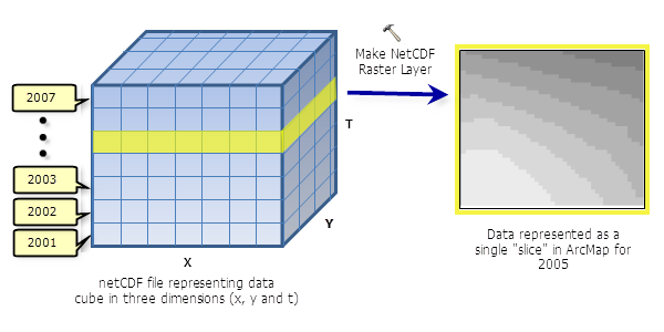
Network Common Data Form(netCDF)은 온도, 습도, 기압, 풍속, 방향 등 다차원 데이터(변수)를 저장하기 위한 파일 형식이다. 위 그림과 같이, 레이어나 테이블 뷰는 큐브에서 하나의 슬라이스를 보여준다. netCDF 내부에 있는 데이터 특징은
- Self-Describing
- Portable
- Scalable
- Appendable
- Sharable
- Archivable
이며, 더 자세한 설명은 여기를 참고하면 된다.
ArcGIS Pro에서 사용할 수 있는 netCDF 관련 툴
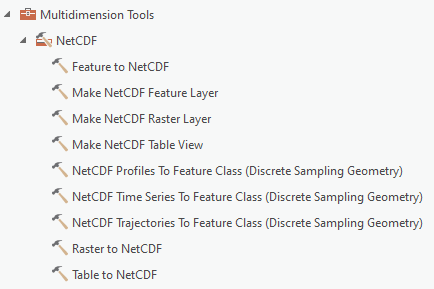
ArcGIS Pro에서는 NetCDF 툴 세트 안에 있는
- Feature to NetCDF
- Make NetCDF Feature Layer
- Make NetCDF Raster Layer
- Make NetCDF Table View
- NetCDF Profiles To Feature Class (Discrete Sampling Geometry)
- NetCDF Time Series To Feature Class (Discrete Sampling Geometry)
- NetCDF Trajectories To Feature Class (Discrete Sampling Geometry)
등의 툴을 활용할 수 있다.
netCDF에서 사용하는 어휘
- Dimensions(차원): netCDF의 차원은 이름과 크기를 모두 갖는다. 크기는 임의의 양의 정수이다. 실제 물리적 차원(시간, 위도, 경도, 높이 등)을 나타낼 때 사용할 수 있다.
- Variables(변수): 동일한 유형의 값 배열의 의미한다. 대부분의 데이터를 netCDF 파일에 저장할 때 사용한다.
- Coordinate variables(좌표 변수):
- Attributes(속성): 보조 데이터 또는 메타데이터를 저장할 때 사용한다.
- Conventions(규칙): 각 변수의 데이터와 해당 시공간 속성에 대한 설명을 제공하는 메타데이터를 정의한다.
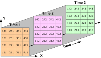
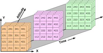
netCDF 데이터 저장 구조
netCDF에서 데이터는 array(배열) 형태로 저장된다.
시간에 따라 달라지는 온도는 1차원 배열에 저장되고, 시간에 따라 달라지는 지역의 기온은 2차원 배열에 저장된다.
시간에 따라 달라지는 지역의 기온(3차원 데이터)과 시간과 고도에 따라 달라지는 지역의 기온(4차원 데이터)은 2차원 배열의 연속으로 저장된다.
netCDF 샘플 데이터
Example netCDF files
Example netCDF files Below we provide links to some sample netCDF files. These may be useful to developers of netCDF tools who want to test their tool on real data rather than small artificial examples. Some of these files are quite large, which is another
www.unidata.ucar.edu
참고 자료
What is netCDF data?—ArcGIS Pro | Documentation
What is netCDF data? NetCDF (network Common Data Form) is a file format for storing multidimensional scientific data (variables) such as temperature, humidity, pressure, wind speed, and direction. Each of these variables can be displayed through a dimensio
pro.arcgis.com
A quick tour of netCDF data—ArcGIS Pro | Documentation
A quick tour of netCDF data NetCDF (network Common Data Form) is a file format designed to support the creation, access, and sharing of scientific data. It is used extensively in the atmospheric and oceanographic communities to store variables, such as tem
pro.arcgis.com
Including netCDF Dimension Values in the Name of an Output Layer or Table
NetCDF (network Common Data Form) is a file format for storing multidimensional scientific data (variables) such as temperature, humidity, pressure, wind speed, and direction. Each of these variables can be displayed through a dimension (such as time, date
www.esri.com
'GIS > ArcMap' 카테고리의 다른 글
| [ArcGIS Pro] point 데이터로 시공간 큐브(netCDF) 만들기 (0) | 2023.02.09 |
|---|---|
| [ArcGIS Pro] text 필드를 date 필드로 새로 만들기 (0) | 2023.02.09 |
| [ArcMap] polygon을 원하는 크기의 grid로 나누기 (0) | 2023.02.01 |
| [ArcMap] 여러 shp 파일을 하나로 합쳐서 내보내기 (0) | 2023.01.18 |
| [ArcMap] 선택한 객체로 새로운 shp 파일 만들기 (0) | 2023.01.18 |


